Flood-hit areas have experienced further disruption after Storm Jorge battered the UK with strong winds and heavy downpours.
The latest bout of extreme weather comes after the country experienced the wettest February since records began.
Data from the Met Office shows that an average of 202.1mm of rainfall fell last month, surpassing records for February 1990 when 193.4mm fell. By lunchtime yesterday, 84 flood warnings remained in place across England, including many in east Yorkshire.
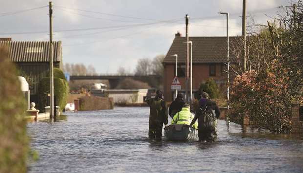
In Snaith, where residents were evacuated from their homes earlier in the week, the environment agency has deployed another four pumps to the 18 pumps already installed to reduce flooding in the town.
East Riding council has urged residents living in affected areas to “remain vigilant” as the deluge continues, although there were no evacuations in the region for the first night since flooding started.
Overwhelmed flood barriers at Ironbridge in Shropshire, which also lead to an emergency evacuation, were fixed on Friday, while a severe weather warning –meaning danger to life – was also downgraded.
However, the Environment Agency yesterday reported that water levels in the area were rising again and were expected to peak between 5.4 and 5.7m today afternoon. Telford and Wrekin council said levels would hopefully be at least a metre lower than last week, while more local businesses were reopening.
On Saturday, when many yellow Met Office warnings for rain remained in place, several flooded roads were closed in Wiltshire and people were rescued from cars stranded in both Devon and Somerset.
The area surrounding the River Ouse, along which some flood warnings remained in place yesterday, was also temporarily closed to high-sided vehicles in Humberside as winds reached up to 70mph.
In south Wales, police declared a critical incident during Britain’s fourth weekend of downpours, with Pontypridd and the Ely area of Cardiff among the worst affected areas.
Residents were advised to stay indoors to avoid winds of up to 70mph and were told that water levels could rise further.
A number of flights were diverted to Northern Ireland from the Irish Republic because of high winds across the island, while a lorry overturned as winds battered the N59 road in Galway.
Only one yellow weather warning for snow was in place across parts of Scotland yesterday, while ice is expected to form in north-western England and Scotland, bringing disruption to commuters today morning.
National Rail said many services were still disrupted because of damage caused by the storm.
A bus replacement will be in place between Aberdare and Pontypridd until Wednesday after the line was damaged, while a section of the Conwy Valley line between Blaenau Ffestiniog and Llandudno, is still closed due to damage caused by Storm Ciara.
Although the weather is expected to clear in part during the first week of March, the Met Office said there was a chance of more persistent rain, hill snow and strong winds before Thursday.
Storm Jorge is the third storm to hit the UK this month, while 15 rivers in the Midlands, Yorkshire and Lancashire have recorded their highest levels on record this winter. The department for environment food and rural affairs said more than 3,300 properties in England were thought to have flooded as a result of Storm Ciara and Storm Dennis, which hit the country earlier in the month.

Local people go door to door using a boat collecting belongings and helping residents in the rising floodwaters in East Cowick, northern England, yesterday.
