The greatest animal migration on Earth is likely something you never heard of and few have witnessed: legions of tiny marine creatures rising to the ocean surface every night to feed on tiny plants, then sinking back into the deep, dark water at dawn.
Called the diel vertical migration, it was first recorded nearly 200 years ago by hauling ship nets through the water column. Today, marine scientists still sample the movement using shipboard nets. They also shoot acoustic signals into the water to track the sound “backscattering” off the zooplankton as they migrate up and down. Some collect data from aircraft, deploying a lidar system that uses a kind of laser radar to create the backscatter.
But such methods take time and resources and are limited.
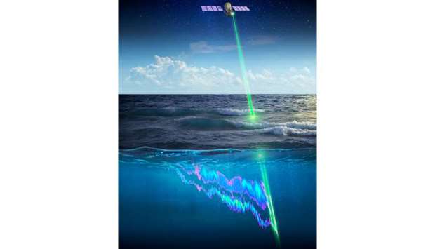
Then, a couple years ago, oceanographers working with Nasa Langley Research Center in Virginia discovered that Nasa’s CALIPSO orbiting satellite and its lidar instrument — built to study clouds, not oceans — has been collecting data on this migration on a global scale by happenstance since 2006.
Scientists were astonished — and delighted.
“The lidar has given us our first measurements of animals — in fact, animal behaviour — from space,” said Michael Behrenfeld, a biological oceanographer at Oregon State University. “What (it) has allowed us to do for the first time is actually to study this migration on a global scale every 16 days for 10 years. And that’s a very powerful place to be.”
Behrenfeld is lead author of a paper on this research that recently published in the science journal Nature.
Behrenfeld has collaborated for years with Yongxiang Hu, an atmospheric scientist at Langley, on ways to use Nasa’s current assets in space to collect ocean data. Measurements taken by CALIPSO’s lidar instrument, called CALIOP, enabled him to study plankton biomass in the surface oceans, for instance, and changes in polar ecosystems.
Then one night on a research cruise in the North Atlantic, Behrenfeld noticed a wedge of phytoplankton eaten away by migrating animals in a very short period of time.
“I looked at it and said, ‘This is something I need to pay attention to,’ ” Behrenfeld recalled.
Later, a colleague showed him data from daytime field measurements of migrating zooplankton taken using optical signals.
“When I saw that, the light bulb turned on,” Behrenfeld said. “I knew what I wanted to do and I needed people from Langley to help me do it.”
Collaborating again with Hu and others, he compared those daytime field measurements with CALIOP’s nighttime measurements and, sure enough, found a signal of the migration.
These tiny marine animals migrate for one important reason, explained zooplankton expert Deborah Steinberg, chairwoman of the Department of Biological Sciences at the Virginia Institute of Marine Science and a study co-author.
“The main purpose of it,” Steinberg said, “is to avoid getting eaten.”
But, while the goal is to escape visual predators by keeping to the dark, she said, their migration also plays a key role in something far bigger: removing carbon dioxide from the atmosphere and sequestering it in the deep ocean, where it doesn’t contribute to global warming.
The so-called carbon conveyor belt works like this: CO2 from the atmosphere diffuses into the ocean surface, where microscopic marine plants use it for photosynthesis. Zooplankton eat those plants and retreat back to the ocean deep, where they digest the food and release the carbon when they defecate.
This carbon movement is considered so important to the planet’s climate, said Behrenfeld, that CALIOP’s dataset is being integrated into global climate models.
CALIOP also unearthed a puzzle about migration strength. Generally speaking, he said, migration strength seems to go up and down along with phytoplankton production, which in turn correlates with ocean surface temperatures and, therefore, climate.
But there are significant regions of the Atlantic where that relationship looks like it’s the opposite, he said, and scientists don’t understand why.
“Any kind of discovery like this opens a whole boxful of new questions,” said Behrenfeld. “What we really are going to need to do this right is a satellite lidar that is actually designed to do ocean studies, and not just rely on an atmospheric instrument.”
Such an instrument has been developed at Langley, and is undergoing field tests on aircraft, said Chris Hostetler, a Nasa project scientist who helped develop the CALIOP. Behrenfeld and Hu are helping to design the new instrument.
“That will open up a whole new level in science,” Hostetler said. “It’ll be a new frontier.”
But, while the technology is there, he said, they’re still looking for the funding and opportunity.
“In science, there are a lot of good ideas out there,” said Hostetler. “It takes years to convince the scientific community and to convince the funding agencies that a certain idea is worth spending a few hundred million dollars on, because that’s what it takes to put up a satellite of the nature we’re talking about.”
Even the CALIOP took time to get approval and funding against doubts that a lidar system could work reliably in space. Finally, it was launched into orbit in 2006 on a three-year mission and soon proved that it could. The lidar is still plugging away, a decade past its expiration date. Hostetler said its datasets have spawned more than 2,000 articles in scientific journals, mostly on atmospheric science.
“The fact that it came to be used for ocean research, it really was astounding to me,” Hostetler said. “We weren’t even dreaming of that.
“To say that it’s a huge success is really an understatement. It’s been transformational in terms of atmospheric remote sensing.”
Even if the CALIOP goes dark tomorrow, said Hostetler, “the dataset from the past 13 years is still in the bank, and people will be analysing that data in different ways for years to come.” — Daily Press (Newport News, Virginia)/TNS