 |
|
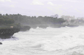
Waves break on the shore in Santo Domingo yesterday as the Caribbean Sea is churned up by |
On its current path, forecasters said the storm after sweeping over Haiti will hit Cuba and the southern tip of Florida before possibly making landfall anywhere from the Florida Panhandle or Alabama to as far west as New Orleans.
The US National Hurricane Centre (NHC) has had a tough time projecting the exact track and long-term intensity of the large and poorly organised storm.
The NHC is no longer forecasting Isaac to rev up to hurricane force until long after it crosses Haiti, where thousands of people are still living in tents and makeshift shelters after a devastating earthquake more than 2-1/2 years ago.
Isaac’s projected track has drifted westward since Thursday, potentially increasing the storm’s threat to US energy interests in the Gulf of Mexico.
The NHC said Isaac was centred about 185 miles (300km) south-southeast of the Haitian capital Port-au-Prince late yesterday morning, packing top sustained winds of 60mph (95kph).
The storm was moving west-northwest at 14mph (22kph), and some additional strengthening was possible before Isaac’s centre passed near or over Haiti overnight.
Flash-flooding and mudslides, which are common in the poorest nation in the Americas, could add to the misery of about 350,000 quake survivors housed in tent cities and camps after the January 2010 disaster. Reuters