Reuters/New Orleans
Tropical Storm Lee crawled onto southern Louisiana’s coast yesterday as New Orleans prepared for one of the biggest tests of its flood defences since Hurricane Katrina devastated the city in 2005.

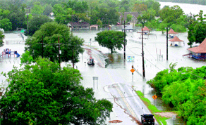
Water floods a street and park as Tropical Storm Lee slowly makes landfall in Lafitte, Louisiana, yesterday. Tropical Storm Lee crawled onto southern Louisiana’s coast as New Orleans prepared for one of the biggest tests of its flood defences since Hurricane Katrina devastated the city in 2005
The National Hurricane Center said Lee’s centre was about 125 miles (200km) west-southwest of New Orleans, with maximum sustained winds of 45mph (72kph) at around 11am EDT (1500 GMT), and tropical storm-force winds extending 275 miles (445km).
Winds were expected to weaken gradually in the next couple of days and up to 20in (51cm) of rain was expected to fall on southeast Louisiana, the Miami-based centre said.
In New Orleans, the storm recalled Hurricane Katrina, which flooded 80% of the city, killed 1,500 people and caused more than $80bn in damage to the popular tourist destination. Lee has dropped nearly 11in (28cm) of rain on New Orleans since it developed late last week.
Half the city lies below sea level and is protected by a system of levees and flood gates.
The levees can process about 1in (2.5cm) of rainfall per hour and the storm’s slow-moving nature remained a worry, officials said. There were isolated reports of flooding in roads and homes. No injuries or fatalities were reported.
New Orleans officials were cautiously optimistic that the pump system would stay ahead of the rainfall, as residents awoke yesterday to the arrival of a heavy band of rain.
“There’s not a whole lot of flooding anywhere, so things are OK,” said Jerry Sneed, deputy mayor of public safety. “We’re ready for the next round.”
Low-lying parishes around New Orleans did not fare as well, as Lee’s winds drove a tidal surge over levees and onto roads.
“For a while we got some false hope that we might be out of the woods, but we realised overnight we would get more rain,” Lafourche Parish spokesman Brennan Matherne said. “We’re getting call after call about street flooding.”
In Jefferson Parish, where some residents are under mandatory orders to evacuate, bulldozers and dump trucks moved earth to bolster levees.
And on Grand Isle, a barrier island at the mouth of Barataria Bay, Lee pushed a tidal surge inland.
“It comes from all over. It seeps through,” island Mayor David Camardelle told local television. “In 30 minutes you can get 2-1/2ft of water.”
New Orleans is under a flash flood watch through Monday night, the National Weather Service said. Potential damage from wind gusts will also be a concern, it said.
Lee’s tidal surge could spur coastal flooding in Louisiana, Mississippi and Alabama before drenching a large swath of the Southeast and Appalachian regions in the coming days.
Storm winds were already pushing Gulf waters inland, slamming barriers in low-lying areas and prompting mandatory evacuations in the coastal communities of Lafitte, Crown Point and Barataria.
In Mississippi, local governments were taking precautions as forecasters predicted tides could be 2ft to 4ft (0.6 to 1.2m) above normal.
About 11,500 houses were without electrical power due to the storm late on Saturday, down from about 38,000 earlier, according to utility Energy Corp.
More than 60% of US offshore oil production, all based in the Gulf of Mexico, and nearly 55% of offshore gas production were shut as of Friday, according to the US government. Most of that output should quickly return once the storm passes.
Major offshore producers like Royal Dutch Shell, Exxon Mobil Corp and BP Plc shut down platforms and evacuated staff last week.
Shell and Anadarko Petroleum Corp started to return workers to offshore platforms in the western Gulf of Mexico on Saturday.
Low-lying refineries in Louisiana that collectively account for 12% of US refining capacity were watching the storm closely, but reported no disruptions.