


 |
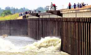
| Members with the US Army Corps of Engineers open the Morganza Spillway in Louisiana on Saturday |
The US Army Corps of Engineers on Saturday opened two of the 125 floodgates at the Morganza Spillway 45 miles (72km) northwest of Baton Rouge, and expected to open two more yesterday.
Opening the floodgates - a move last taken in 1973 - will channel water away from the Mississippi River and into the Atchafalaya River basin. That will take the floodwaters toward homes, farms, a wildlife refuge and a small oil refinery but avoid inundating New Orleans and Louisiana’s capital Baton Rouge.
In Amelia, about 100 miles south of the spillway, crews worked around the clock to build earthworks and reinforce levees ahead of a torrent of water that is expected to reach the area today or tomorrow.
“I hope they know what they are doing,” said Hue Tran, watching the giant dump trucks from the Quik General food store, a short distance from the intercoastal waterway.
“I hope it will give us a little bit of peace but we’re scared that the water will come over,” said Tran, who has operated the store for 25 years.
Tran is prepared to evacuate if government officials give the word. Farther north, parts of St. Landry Parish already were under a mandatory evacuation order.
Weeks of heavy rains and runoff from an unusually snowy winter caused the Mississippi River to rise, flooding 3mn acres of farmland in Mississippi, Tennessee and Arkansas and evoking comparisons to historic floods in 1927 and 1937.
Louisiana towns in the path of the floodway like Krotz Springs, Butte LaRose and Morgan City are making similar plans for severe flooding that could be sustained for three weeks before the water works its way to the Gulf of Mexico.
About 2,500 people live in the spillway’s flood path and 22,500 others, along with 11,000 buildings could be affected by backwater flooding - the water pushed back into streams and tributaries that cannot flow normally into what will be an overwhelmed Atchafalaya River.
Some 3,000 sq miles (7,770 sq km) of land could be inundated in up to 20ft (6m) of water for several weeks. When flows peak around May 22, the spillway will carry about 125,000 cu ft per second, about one quarter of its capacity.
Some 18,000 acres (7,300 hectares) of cropland could be flooded as waters rise, hitting their crest in about a week.