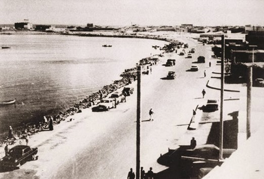
The Corniche in the 1950s.
Of the several interesting community educational projects that saw the light of day this year, the one that stands out for its goldmine of information and neat execution is an interactive, multi-media map of the city titled Doha Online Historical Atlas (DOHA) – and its collection of material is only getting richer as we enter 2016.
The Origins of Doha is a University College of London Qatar (UCL Qatar) research project, supported by the Qatar National Research Fund and aims to explore the foundation and historic growth of Doha, its transformation to a modern city, and the lives and experiences of its people, through a combination of archaeological investigation, historical research and oral testimony.
A couple of months ago, DOHA was launched as part of the output of UCL Qatar’s Origins of Doha and Qatar Project, a QNRF-funded interdisciplinary programme that explores the story of the town and its people through a combination of archaeological excavation, historical research, architectural studies, GIS analysis and ethnographic techniques – particularly oral histories.
At the click of the mouse, you can travel back in time – as far as eight decades back – to understand how Doha has evolved over the years to become this ultra-modern city of today. Do log on to www.spatialheritage.org/doha
“This interactive web resource presents some of the project’s research, tracing of the changing physical extent and urban configuration of Al Bidda and Doha through time, using historic maps, photographs, historic building recording and the excavation of archaeological deposits,” the website says.
Arguably, DOHA is the first project in the Middle East to use state-of-the-art technology to build such a meticulous map of the city. Currently, the map is in the BETA version and includes old photographs of places and people over the decades, various aerial images, and dozens of historical nuggets such as video footage from the 1960s showing city landmarks.
“DOHA is an interactive GIS mapping tool that allows users to zoom in and out of localities using a choice of historic backgrounds (maps and early aerial overheads) which can be faded out or in to overlie today’s map. Users can click on geolocated resources such as historical photos, film clips, fieldwork reports and photos by the Origins team, and maps of the historic districts,” UCL Qatar says. Most of the precious content documents the 1940s-1960s period and more material is being added to the site’s information storehouse, thanks considerably to its plea of asking visitors to donate material by uploading them to the project’s crowdsourcing site.
According to Dr Robert Carter, professor of Arabian and Middle Eastern archaeology at UCL Qatar: “The most interesting and unpredictable aspect of this study is the inclusion of crowd-sourced data. We are always looking at new ways to engage the people of Doha in their heritage, both Qatari nationals and expatriates, and by encouraging people to contribute their own resources and experiences we hope to boost this process.”
Sample a couple of entries on Doha’s Historical Timeline, as detailed on the website: First mention of Bida’ (now Doha) in 1680 – Bida’ was the first part of Doha to be founded, and was later absorbed into the larger town of Doha, which originally began as a separate settlement. The first possible mention of Bida’ is in a French missionary source of the Carmelite Convent, which refers to a sheikh and fortress at “Bride”. In a list of place names going round the coast after Zubara and Huwaila, it is in the correct position to refer to Bida’.
Speaking of Development in Doha attributed to the year 1955 on the timeline, the entry pulls out a few paragraphs from the book Rediscovering the Island: Doha’s Urbanity from Pearls to Spectacle: “It was around 1955 that a true sense of development began to be felt in the city. Asphalt roads were extended and lit; a new desalination plant was constructed with pipes connecting it to many houses nearby; an electric plant was built in Kahraba Street near Mushereib; new schools began admitting students; and a new hospital, Al-Remailiah, opened its doors for the first time in the country, followed by maternity and children’s hospitals.”
The excerpt further points out, “To accommodate the population growth and the changing urban life, the government of Qatar in 1972 contracted the first foreign planning consultant, the British-based Llewelyn-Davies, to supply a master plan for Doha extending through to 1990. Llewelyn-Davies presented several proposals for different parts of the city and advised the Planning Department of the Ministry of Municipal Affairs on planning legislation. One of their recommendations for the central areas of the city was to acquire a number of older neighbourhoods from their residents and clear them for redesign and redevelopment.”
