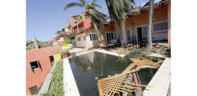
Debris is seen outside luxury vacation homes in Costa Careyes, after the passing of Hurricane Patricia, in the Mexican state of Jalisco on October 25. Less than eight people are known to have died in the storm, compared to over 6,000 in Super Typhoon Haiyan.
By Steff Gaulter
The strongest tropical cyclone ever recorded has slammed into Mexico. The storm, called Hurricane Patricia, was even stronger than Super Typhoon Haiyan, which slammed into the Philippines in November 2013. Haiyan killed at least 6,000 people and flattened much of the city of Tacloban, so as Patricia bore down on Mexico, many people feared the worst.
Fortunately, Mexico was spared a disaster similar to that seen in the Philippines. Less than eight people are known to have died and many people are now asking how the country managed to escape.
As I mentioned in last week’s Weather Addict, there is no difference between a hurricane and a typhoon, they are simply given different names in different parts of the world. Super Typhoon Haiyan was estimated to have winds of 313 kph (195 mph), whereas Hurricane Patricia was slightly stronger with winds of 321 kph (200 mph). Both were clearly very powerful storms, but Patricia is thought to have been marginally stronger.
I say ‘thought to have been’ because the strength of the winds in Haiyan were estimated. It is highly unlikely that a storm of this magnitude would pass directly over a weather observation station, and if it did it would probably break it, so the winds of Haiyan were estimated from satellite images. In the case of Patricia, the winds were measured by an aircraft on a reconnaissance mission. This means there is a margin of error in the estimation of Haiyan’s wind speed, but clearly both storms are incredibly strong, with winds of a comparable strength.
Despite the winds of the storms being similar, the damage inflicted by the two storms was like chalk and cheese. This clearly shows that there is far more to forecasting the possible destruction caused by a cyclone, than simply looking at the speed of the wind.
The fact that Mexico was largely spared the devastation which struck the Philippines is due to a fair amount of luck because the part of Mexico that was hit by Patricia was sparsely populated. The storm passed between the cities of Puerto Vallarta and Manzanillo. Haiyan, on the other hand, struck a densely populated city which was full of rustic homes, many of which were wooden structures with corrugated iron roofs. These were no match for such a powerful storm, and were quickly flattened.
Like all hurricanes and typhoons, both Patricia and Haiyan had the strongest of the winds in the centre of the storm. The most powerful winds rotate around an ‘eye’, with the winds dropping sharply away from the centre. The diameter of the eye of both storms was about 15 kilometres (9 miles). Despite the centre of the storms being similar, Hurricane Patricia was a smaller storm, because away from the centre the winds dropped away more quickly. When Patricia made landfall, hurricane force winds only extended about 50 kilometres (30 miles) from the centre. In the case of Haiyan, however, it’s estimated that fourteen million people were affected by winds that were at least the equivalent a category one hurricane in strength.
The topography of the area also played a huge role in determining the amount of damage. A tropical cyclone usually loses strength as it moves across land. This is due to two main reasons, firstly the sea is the energy source of these tropical systems, so once it’s over land it would lose steam, and secondly land isn’t as smooth as the surface of the sea, so the additional friction slows down the storm. Unfortunately for the Philippines, the small islands that Super Typhoon Haiyan passed over were all fairly low-lying, meaning that the friction applied to the storm was minimal.
In the case of Patricia, however, the storm came ashore along part of the coastline which had a very steep terrain. This quickly killed the hurricane and in 24 hours, the winds had dropped from 305 kph (190 mph) to 50 kph (30 mph), a staggering loss of 255 kph (160 mph).
As well as losing strength very quickly, Patricia had also intensified very quickly. In fact it was one of the most rapidly intensifying cyclones ever observed, dropping an astonishing 100mb in 24 hours. Whereas this may have made forecasting the storm more difficult, it also ensured the storm wasn’t able to exert a sustained force on the sea and push a huge volume of water towards the coast. This, plus the fact that the sea along the Mexican coastline isn’t shallow, ensured that Mexico wasn’t hit by a particularly devastating storm surge.
In the case of Haiyan, however, it was the storm surge that caused the worst of the damage in Tacloban. Tacloban lies at the head of a bay, causing the storm surge to be funnelled between the islands of Leyte and Samar. The giant storm surge of over five metres (16 feet) high was higher than most of the city, and had the same effect as a tsunami. We all saw the devastation that a tsunami can do after the earthquake in Indonesia in 2004, or the one in Japan in 2011. The wall of water in the eastern Philippines was no different, it bulldozed houses and flattened everything in its path.
These subtle but important distinctions between the two storms lead to a vast contrast in the loss of life they caused. The Mexican civil defence can also congratulate itself on its efforts of evacuating people out of harms way. However, it is important that the population does not become complacent, as if this storm had struck a few hundred kilometres west, or east, then the outcome could have been very different.