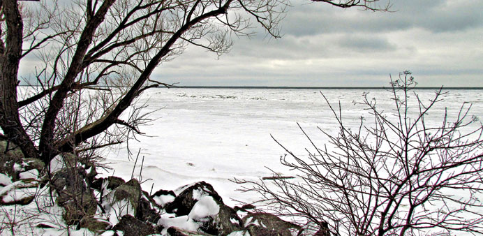

FREEZE, FROZE, FROZEN: More than ninety per cent of Lake Erie was frozen over in a stunningly cold spell seen lately.
By Steff Gaulter
It always amuses me how the media can jump on a term and flog it to death. Who can forget ‘snowmaggedon’? This time, as the cold air forced its way across North America, it was the term ‘Polar Vortex’ which was repeated ad infinitum.
I doubt anyone really knew what it was, but who cares when it sounds so impressive? At least it wasn’t a made up word!
A polar vortex is not quite as scary as it might sound, it’s simply the area of cold air over the Arctic, also known as the polar low. In the winter, the North Pole endures twenty-four hours of darkness and without the sun, temperatures drop to an average of -40°C (-40°F). Normally this cold air sits above the North Pole very happily and disturbs no-one at all, except perhaps a few Inuits.
The air over the North Pole is so cold that it sets up a weather pattern of its own. A strong wind blows in a circle around the edge of the cold air, high up in the atmosphere. This actually has the effect of trapping the cold weather in its place at the extreme north of the globe.
Whilst this wind blows, the cold air remains over the Arctic, but if the winds weaken, cold air can rush southwards, as if someone has left a freezer door open.
This rush of air does happen every now and then, and isn’t as rare as you might think. It’s the reason that the last few winters have been so cold over northwest Europe.
This year, however, it was North America which saw an icy blast, and it was a far more extreme blast than usual. An area of high pressure developed over northeast Canada, which disrupted the usual flow of the air over the north of the globe. A large portion of the cold air was forced across southern Canada and the US. Temperatures dropped dramatically as the cold air dug right across North America and into Florida.
On January 6, at the height of the Arctic blast, the temperature in Minneapolis struggled to reach its daytime high of -25°C (-13°F).
The night time low was a bone-chattering -30°C (-22°F), but as cold as this was, it was actually the wind that caused the real problem. A wind draws heat from your body and increases the speed that your body loses heat. Therefore, a wind can make the weather feel far colder than it actually is.
Taking the extra cooling generated by the wind into account, the coldest weather which was recorded during this recent snap was in Comertown, in the state of Montana.
While the wind whistled through the streets at 53kph (33mph), the thermometers measured a temperature of -32°C (-26°F). The wind meant the temperature felt more like -53°C (-62°F). I can’t even imagine how that must feel.
As well as making the weather feel even colder, a wind also reduces the amount of time that it will take for you to suffer frostbite.
In this latest cold snap, people were advised to avoid going outdoors altogether, as frostbite could occur on exposed skin in less than ten minutes.
The temperatures were so low that it was too cold for the roads to be cleared using the usual method of scattering salt on them. This usually melts the ice, but can only work at certain temperatures.
As you no doubt know, water begins to turn to ice at 0°C (32°F), but if salt is added to water, the mixture has a lower freezing point. The exact temperature at which it freezes depends on how much salt is in the mixture. A ten percent salt solution freezes at -6°C (21°F), and a twenty percent solution freezes at -16°C (3°F).
This trick of adding salt also works if the water has already turned to ice, because there is a thin film of water on the surface of ice. This tiny amount of water is enough for the salt to start working.
You can actually watch this process happening, firstly the melting will start immediately around the grains of salt, and then slowly spread out from this point. However, if the temperature of the road is lower than -9°C (16°F) or so, then the salt won’t have much of an effect.
As the winds blew over the vast Great Lakes, they picked up a lot of moisture. This was then deposited as snow downwind of the lakes in huge volumes. In Buffalo, New York state, 32cm (12.6 inches) of snow fell, making many roads impassable.
The snow gradually tapered off the following day, not because of a change in wind speed, but thanks to the incredibly low temperatures. The extreme cold meant the lakes froze more than usual. The Great Lakes were covered by their highest ice coverage for twenty years and more than ninety percent of Lake Erie was frozen over.
The bitter weather brought the coldest air seen over the region since the Arctic blast of 1996, but it wasn’t unprecedented. Nowhere recorded a lowest ever temperature, in fact the most unusual thing about this cold snap was the fact it had been absent for so long. Before 1996, cold waves of this intensity occurred every five to ten years. This time we had to wait eighteen years. So for the few people in North America who may be thinking ‘so much for climate change’, the cold snap is actually a little more proof.