A paddle at the beach is one of the pleasures of a hike on Maria Island, Tasmania. Photograph: Maria Island Walk
By Christian Roewekamp
Adam Kilvert has nerves of steel, and guts. The manager from Brisbane is crawling on his belly, high up on the twin peaks of Bishop & Clerk on Maria Island, inching his way forward. Then he sticks his head over the edge — for a view plunging virtually 600m vertically downwards.
“Be careful,” his girlfriend Margie urges as Adam stretches his arms out over the edge with a camera in hand to photograph the waves of the South Pacific crashing against the cliffs below.
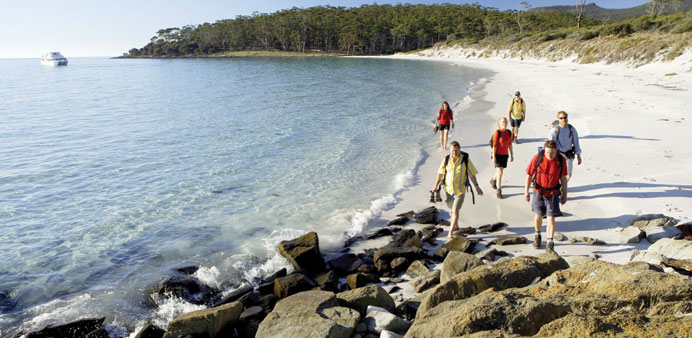
Maria Island is a small island off the eastern coast of Tasmania, once an outpost of Australia and a national park. The tour up Bishop & Clerk is one of the most popular activities, requiring four to five hours, there and back, from Darlington, the island’s only town.
The trail first goes through hilly grasslands, then a eucalyptus forest, and later winds upward 150m through rocky terrain. At the very end there are some boulders to clamber over before finally the hiker is rewarded with a magnificent view. Off in the distance lies Tasmania, a 30-minute ferry ride away.
The Bishop & Clerk hike is one of just many organised treks offered on Tasmania. Six tour operators have joined together in offering the “Great Walks of Tasmania” covering various regions of the island.
The range of hikes can be anything from the four-day, fairly easy walks along the oceanside, as on Maria Island or Freycinet National Park in the north, to the 9-day and rather challenging South Coast Track. But hikers who head out on their own still make up the majority. And those who don’t have their own equipment can rent sleeping bags, tents and cooking gear before starting out.
In Freycinet, the departure point for many treks is Coles Bay, which is fairly easy to reach, something that does not apply to all the trails. Without some careful planning, a hiker might quickly run up against his or her limits.
And, reservations may be necessary in places due to demand and to curb overcrowding. Camping spots in Freycinet park have to be booked in advance during the high season. On the Overland Track covering 65km from Cradle Mountain to Lake St Clair, a maximum of 34 hikers are permitted daily: people who have booked far in advance and who, from November to April also have to pay a fee.
“The fee was raised to $A200 ($189) per person in 2012 in order to regulate the demand for the Overland Track more forcefully,” notes Annabelle Sweetman, hiking expert for Tourism Tasmania.
Those who make a booking at Cradle Mountain Huts need not worry about paying the trail fee, and when they get there, they won’t be sleeping in a tent, but rather in a comfortable cabin. But the guest pays a higher price for the service, of course.
Back on Maria Island, Adam Kilvert has packed his camera away, and before he starts his descent from Bishop & Clerk, he scans the panorama of Maria Island. One of the sights is the Painted Cliffs, limestone formations of brown, ochre and yellow colours which are easily accessible at ebb tide.
The main town of Darlington is largely hidden behind trees. Back in the 19th century, it was for 15 years a prison set up by the British. Some of the buildings from back then are still standing, including the well-preserved Commissariat Store from 1825.
Later on, Diego Bernacchi of Italy had dreams of setting up a business empire on Maria Island. He set up silk production, planted vineyards and went into the cement business. All that remains of these ambitions are a few ruins, although the four cement silos built in 1922 in the harbour still capture visitors’ attention. Today, Maria Island is a protection zone for the Tasmanian devil, a small marsupial whose existence on the main island is threatened by an infectious disease causing facial tumours.
Last November, the first 15 Tasmanian devils were acclimatised on Maria Island in a bid to protect them from extinction. It’s a rarity for hikers ever to spot one of the shy creatures.
Another excellent hiking region is the rainforest of Tarkine on the north-western part of Tasmania. The problem many people have, however, is finding the marked trails, because the starting points are remote in forests covering an area over 2,500 sq km.
Help to find the first signposts comes from somebody like Rob Fairlie, who in his all-terrain vehicle drives the gravel roads west of Waratah taking hikers to the trail starting points as part of the service of his Tarkine Trails company.
People also can stay overnight in tents he has set up, equipped with cots. Far removed from any mobile telephone networks, guests can truly get away from it all in this remote corner of the planet.
The rainforest itself is dense with laurel, myrtle and eucalyptus trees, some of which can grow to heights of 70m. “When they topple over at some point, they want to burn up, it belongs to their life cycle,” Rob says. “But when the myrtle plants fall over, they absorb lots of water and so survive further when a fire comes. So there’s a constant life-and-death struggle going on here.”
The campground at Tiger Ridge is the main base for day-long hikes of this nearly untouched and remote region. “From here, it’s 50km to the ocean to the west. The nearest roads are 40km to the north and 20km to the south and east,” Rob says.
A threat to the Tarkine region lies in the fact that it is rich in mineral resources. The Mount Bischoff mine near Waratah was once considered to have the richest tin deposits in the Southern Hemisphere, and iron ore and silver are also mined in the area.
Nature preservationists dream of one day seeing a Tarkine national park created, stretching to meet the Cradle Mountain Lake St Clair National Park. Two unique wilderness regions would then be united. – DPA