


By Steff Gaulter
As summer gets into full swing in North America the extremes of weather are causing major problems. In the southwestern states of the USA, fires have destroyed hundreds of homes and caused tragic loss of life, whilst Toronto was all but submerged after an entire month’s rainfall fell in just a few hours. Wouldn’t it be good if we could simply pipe water from one place to another, and use the flood water to put out the flames?
This isn’t as crazy an idea as it might sound. Some parts of the world already move water from rain-rich areas to desert landscapes, over distances of hundreds of kilometres. However, it isn’t done in an attempt to extinguish fires, it’s an attempt to quench the thirst of the population.
Possibly the largest water distribution and storage system is in California. Water has been shifted from the soggy north to the parched south for decades. In the north, some places receive over 900mm (35 inches) of rain per year, but further south, where the majority of the population lives, the rainfall is far less.
In Bakerfield, southern California, the annual rainfall is less than 144mm (5.7 inches). This pitiful amount of rain isn’t enough water to support a large town, let alone a city with a population of more than 300,000 people.
This city can exist because of the water supplied by the California State Water Project, a network of reservoirs, aqueducts, power plants and pumping plants. The project is vast, supplying water to two-thirds of California’s population, 70% of which goes to urban users and 30% to agriculture.
The Water Project has also provided a means of flood control. Previously each spring, in central California’s San Joaquin Valley, the melting snow caused the rivers to swell and overflow. Now that the water is stored and carefully distributed, major cities have boomed along the river banks. The semi-arid desert of the San Joaquin Valley has been transformed into productive farmland, with crops of raisins, cotton and nuts flourishing on the valley floor.
Another part of the world which uses a similar irrigation system is Argentina. Any visitor to the northwest of the country will be astonished that anything can grow in the arid landscape. The region lies to the east of the towering Andes mountains, but the weather flows in from the west.
This means that any rain falls on the western side of the mountains, as the air is forced up over the high ground. Therefore the northwest of Argentina is in what’s known as a rain-shadow. This includes the city of Mendoza, which receives just 223mm (9 inches) of rain per year. However, despite the lack of rain, Mendoza is famed for its production of world-class wine.
The irrigation of the farmland is achieved by a network of water channels, which diverts water from the Mendoza River to the arid plains. The river is fed almost entirely by snow-melt in spring and summer, and is distributed between farmers by opening and closing miniature flood-control gates. The water then flows through different irrigation channels on different days of the week; for example, fields in Uco may receive water on Monday, while Vistalba waits until Tuesday.
This clever system still irrigates the city to this day, supplying water to over 1,200 vineyards and hundreds of trees and plants.
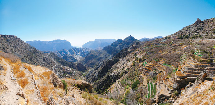
It may surprise you to hear that a similar method of irrigation is also used much closer to Qatar; parts of Oman see quite a substantial amount of rain.
Obviously much of the country is desert, but in the east there are large mountains. As air is forced up over the high ground, it cools. This causes the water vapour to condense into water droplets, forming clouds and rain. In some mountainous locations the rainfall is said to be as high as 900mm (35 inches), which is in stark contrast to the majority of the region which sees under 100mm (4 inches).
To move water down from the mountains, an irrigation network was developed. This differs from that of Mendoza, in that many of the pathways for the water are beneath the ground. The tunnels are known as aflaj, or falaj individually, and some of the oldest are believed to have been built more than 4,000 years ago. The channels of the aflaj extends nearly horizontally, with a series of access shafts approximately every 20m (22 yards). They can be as long as 12km (7.5 miles), which is even more impressive what you consider that they were built by hand, before the days of mechanical diggers. Even to this day people have to enter the small tunnels in order to carry out maintenance. This is very claustrophobic work, given the tunnels are around 0.5 – 1m (1.5 - 3ft) wide by 1 - 2m (3-6ft) high. It is also very dangerous, as an unexpected downpour in the mountains can result in a sudden surge of water.
According to the Ministry of Water Resources, the number of aflaj in Oman is estimated to be 11,000. Some of them, as you might expect, only flow during the winter months, but approximately 4,000 flow constantly throughout the year and is the permanent water source for many regions.
All this goes to show the lengths to which countries will go to find a reliable water supply. Unfortunately, there is no similar option for Qatar, as the rain simply isn’t heavy enough. Instead we must be very grateful for desalination, which allows millions of us to live in the desert.