New number plates have been installed on 90% of buildings in Qatar as part of the unified number project undertaken by the Centre for Geographical Information System (GIS).

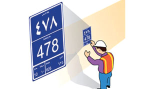
A new number plate
In an interview with local Arabic daily Al-Arab, GIS officials indicated that 85,000 new number plates have already been installed in different areas around the country. They pointed out that this is an important infrastructure project in Qatar, which would benefit all individuals and institutions.
The project is conducted in two phases: First external number plaques are to be installed on all buildings, whether residential, commercial, services or towers. In the second phase, sub-numbers will be given for the units within the buildings whether they were apartments, offices or shops, which would be normally linked to the external number. This second phase is estimated to take two years and would be launched shortly.
Officials said that the first phase is expected to be accomplished very soon. Among the main streets that got their new building numbers are the Airport Street, Najma Street, C-Ring road, B-Ring road and Al-Shafi St. The building number is digitally linked to all the service numbers of the building such as Kahramaa and Qtel as well as the old number of the building, and the street and area number.
All new plaques have Radio-frequency identification (RFID) data chips hidden in them. These include all the related numbers and data of the building and directly linked with the GIS data base. These chips can be read through personal digital assistance (PDA) appliances. These employ information safety standards to avoid any misuse.
Officials explained that this numbering system would make buildings easily accessible for private and public services as well as individuals.
There is already a co-ordination with Qatar General Postal Corporation (Q-Post) to employ this system and use the numbers in delivering mail to homes.
The address would be only the numbers of the house, street and the area. The experimental phase of this project would include parts of the West Bay and Al-Hilal area.
Anybody could access GIS services through GIS website www.gisqatar.org.qa by using one of two programmes: Explore Qatar or Q-land, where all building numbers have been updated. The user could enter the three main numbers of the building (building, street and area) and search for it. Immediately, the location of the place in question would appear on the updated map of Qatar with the routes leading to it.
Two new applications have been recently launched by GIS: Qatar Geoportal, an online programme, which can be accessed by all and contains all the information about the unified numbering for buildings project, and information about more than 3,500 geographical locations and around 6,000 sites around the country.
Private institutions could also get special access to such application to access information related to their work.
The other application is Al-Murshid (The guide), which is a programme for tablets and smart phones. Users can use it in locating any destination in Qatar and the way to reach it.
Regarding the status of buildings in some villages and coastal areas, GIS officials indicated that these places, estimated to be 70 villages and other areas, have been taken into consideration. “Yet, urban planning works in these areas have to be accomplished before the numbering process could begin,” they said.