


Deputy News Editor
 |
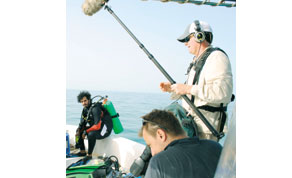
| Saad al-Naimi prepares to dive during filming by National Geographic Television off the coast of northwest Qatar |
QNHER is being developed as part of the Remote Sensing Project, a joint initiative between the Qatar Museums Authority (QMA) under the guidance of head of antiquities Faisal al-Naimi, and the University of Birmingham, where Cuttler is a research fellow.
The Arabian Gulf is a fairly shallow sea and during the Last Glacial Maximum, which occurred about 18,000 years ago, sea levels were more than 100 metres lower than today, explained Cuttler.
This meant that up until 8,000 years ago much of the Gulf was an open landscape with large lakes and a river which was formerly the confluence of the Tigris and Euphrates rivers.
“While our marine archaeologists working in Qatar have not found to date a shipwreck or deposits associated with the former land surface, before the Gulf was flooded, we are convinced that evidence for these periods in the country’s history must remain” asserted Cuttler.
“Detecting such deposits presents a real challenge, but have the potential to inform us about regional environmental changes over many millennia,” he stressed.
To survey the marine areas of Qatar using a team of divers would take many years, particularly given strong regional currents and limited visibility.
However, major advances in marine geophysics in recent years have provided new opportunities to investigate wider areas of the marine landscape and to develop strategies for targeted diver inspections of geophysical anomalies.
The analysis of a large tract of geophysical data off the northwest coast of Qatar revealed more than 80 anomalies with a seabed expression, some of which were clearly modern, and others that were considered to have reasonable archaeological potential.Of the anomalies subject to subsequent diver inspection, none proved to be of archaeological interest.
“However, the visual inspection of geophysical anomalies is providing valuable regional baseline data for the interpretation of anthropogenic marine signatures,” Cuttler said.
The clarification of signatures from different types of anomalies enables the calibration of regionally important geophysical data.“In addition, these inspections have significantly increased our understanding of the seabed characteristics around northeastern Qatar.
“Future geophysical survey will be focused not simply on anomalies but on characterising the submerged landscape using higher resolution geophysical data from a range of sensors,” he revealed.
The work of the marine archaeological team featured in a one hour documentary aired by National Geographic in January this year.
The programme, “Diving into Noah’s flood” generated a lot of interest in the work of the joint team from the QMA and the University of Birmingham.
“Working with National Geographic taught us a lot about the logistical issues of working together with the media,” added Saad al-
Naimi, one of the marine archaeologists involved in the programme.