Hurricane Matthew has brought widespread damage to parts of Caribbean. It churned across the islands at a painfully slow speed, giving a sustained onslaught of destructive winds and excessive amounts of rain. The storm had several strange characteristics, which meant it was even more dangerous than it might have been.
Its development wasn’t particularly out of the ordinary. A cluster of thunderstorms crossed the Atlantic and as it crossed the tiny Windward Islands it developed a circulation in its centre and was classed as a tropical storm. At this point the storm was also given a name: Matthew.
A tropical storm doesn’t only have to have winds circulating around a well-defined centre to be classed as a tropical storm. The winds also need to be over 63 kilometres per hour (38 miles per hour) and importantly, the storm must also get its energy from the warm waters of the ocean; this is what really stands these tropical storms apart from other weather systems which develop in other parts of the world.
Because the energy source of a tropical storm is a warm sea, it stands to reason that most of these storms are usually over open waters. However, the Windward Islands are so small and so low-lying that they have little effect on a storm’s development. Matthew barely noticed the specs of land as it barrelled over them.
Saint Lucia reported over 300 millimetres (12 inches) of rain from the system, triggering widespread flooding. Barbados, Martinique and Dominica were also badly hit by excessive amounts of rain and landslides. In St Vincent and the Grenadines, a landslide crushed a student to death; Matthew had claimed its first victim.
The storm continued to strengthen as it headed westwards, then suddenly exploded in intensity. The storm strengthened dramatically and unexpectedly; in just 24 hours, the winds increased by 120 kilometres per hour (75 miles per hour). This brought the sustained winds in the centre of the storm to 240 kph (150 miles per hour) and even at this point it hadn’t finished strengthening.
Eventually the winds touched 260 kph (160 mph) and the storm was classed as a destructive Category 5 storm on the five-point Saffir Simpson Scale. This is the scale that is used to measure the strength of hurricanes in the waters around the Americas, with one being the weakest and five being the most powerful. Hurricane Matthew was the first category five hurricane in the Caribbean since Hurricane Felix in 2007.
The fact that it had strengthened so rapidly was a surprise to meteorologists, because the system was fighting against strong winds high up in the atmosphere. These winds would usually be expected to blow the top of the storm sideways, essentially pushing over the system, and preventing it intensifying. Clearly Hurricane Matthew was not a typical system.
After reaching a peak of 260 kph, the winds within the storm eased a fraction. Now a category four hurricane, it tracked west, grazing the coast of Venezuela and Colombia. Fortunately the eye of the storm, where the most damaging of the winds are, didn’t make landfall, but they did get surprisingly close. Matthew drew within 120 kilometres (75 miles) of Punta Gallinas in Colombia. This was another surprise, as it is the closest that any hurricane has ever got to South America.
After tracking west, the storm suddenly took an abrupt turn to the north. The track of a storm is usually dictated by other weather features, as it was in this case. A large area of high pressure over the Atlantic had forced the system west, and as Matthew tracked around its western edge, it started to move northwards. However, the system steering Matthew north was very weak, so the storm moved painfully slowly.
As it crept northwards, a patch of incredibly intense thunderstorms developed to its northeast. These thunderstorms were producing even heavier rain than those in the centre of Matthew. They were described by one hurricane expert as ‘inexplicable’. They hit Haiti about 24 hours before the centre of the hurricane made landfall.
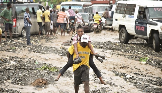
After the intense thunderstorms hit Haiti, came the storm itself. Matthew was the strongest hurricane to hit the country for 52 years. The impoverished country, which is still struggling in the aftermath of the devastating 2010 earthquake, was badly hit. A number of people lost their lives and tens of thousands were made homeless.
At the time of writing this, Hurricane Matthew was heading across the Bahamas. The islands may be battered by strong winds and heavy rains, but the buildings are sturdy and the infrastructure is robust. This means that the islands should be able to withstand much of the severe weather. However, the islands are very low-lying and Hurricane Matthew is pushing a huge wall of water ahead of it. This storm surge is expected to be the largest hazard brought by the storm.
Over the weekend and into the beginning of next week, the hurricane will continue to cause havoc over the east coast of the US. Matthew has proven to be a very long-lasting hurricane, and its legacy is likely to be just as enduring. Matthew’s unusual path, the ‘inexplicable’ storms to its northeast, not to mention its explosive development, mean that it will be studied extensively by meteorologists for many years to come.

DESTRUCTIVE: Haitian people cross the river La Digue in Petit Goave where the bridge collapsed during the rains from Hurricane Matthew, southwest of Port-au-Prince on October 6. Hurricane Matthew has left close to 900 dead in Haiti, a toll that could possibly go up. Photos by AFP
