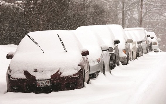
Last weekend a huge winter storm paralysed the east of the US. Blizzards, ice and coastal flooding battered the region, affecting over 80 million people. A state of emergency was declared in 11 states, and over 12,000 flights had to be cancelled.
Some places reported over a metre of snow from the storm, but not only was it powerful, it also covered a vast area. Snow fell across a huge swathe of the US, from northern Florida to Massachusetts, which is a distance of approximately 1,800 kilometres (1100 miles).
Snow wasn’t the only hazard from the storm either. A storm surge swamped parts of the coastal strip, and thick ice coated the landscape of North Carolina. The ice was brought by freezing rain; rain which is liquid as it falls towards the earth, but freezes as soon as it hits the landscape.
Freezing rain coats everything it comes into contact with, from roads and cars, to homes and vegetation. Roads are turned into ice rinks and heavy ice weighs down trees and powerlines. It was this ice, rather than the excessive amounts of snow, which was responsible for the majority of the power cuts from this storm.
As the storm powered up the east coast, it continually pushed water towards the shore. This surge of water was exacerbated by Saturday morning’s high tide, which in turn, was made worse by the full moon. A full moon would be expected to increase the height of a high tide, and on either side of Delaware Bay the moon adds about 30 centimetres (12 inches) to the tide.
The combination of storm surge, high tide and the full moon ensured that a number of locations saw surges that were even greater than those observed during 2012’s Hurricane Sandy. Seawater poured onto the coastline causing major flooding.
For the storm to be this large and this powerful, it needed enormous amounts of moisture. It got this from the Gulf of Mexico, the moisture kindly delivered by a separate weather system that was then swallowed up by the more powerful system that developed off the east coast.
This second system developed rapidly, and headed northwards, remaining just off shore as it did so. As it moved north, it started to throw strong winds and heavy snow towards the east coast. Then suddenly the system slowed. It paused just off the Delaware coast, prolonging its onslaught of severe weather from Kentucky to New York.
The region was coated with a phenomenal amount of snow: Glengary in West Virginia reported 102 cm (40 inches) of snow, Philomont in Virginia recorded 99 cm (39 inches) and Redhouse in Maryland measured 96 cm (38 inches). Not as much fell in New York, but Central Park still saw its largest snowfall in a single calendar day, reporting 67.6 centimetres (26.6 inches), smashing the old record of 61.2cm (24.1 inches) set in 2006.
Measuring snow isn’t quite as easy as it may sound, and unfortunately it’s not quite as simple as going outside and shoving a ruler in the snow. There are many things that can make measurements a little haphazard, including a strong wind blowing the snow and warm weather which might cause the snow to melt.
To try to make the measurements as standard as possible, the US uses a specially designed snowboard. These sound slightly grander than the flat pieces of plywood that they actually are! The boards are painted white to reflect any sunlight and therefore minimise the heating by the sun, and are placed out on the ground away from any buildings.
The boards should be situated in an area that doesn’t usually see snowdrifts, but it needs to be somewhere you can easily locate — it can be hard to find them in deep snow!
Using a snow board may sound pedantic, but it ensures that everyone uses the same base, otherwise some surfaces will produce inflated results, such as measuring snow caught in blades of grass.
The depth of the snow is measured every six hours, and after each measurement is taken, the snow is cleared from the snowboard ready for the next deposit. In order to get the amount of snow in a day, or from a large storm, it is therefore necessary to add together a number of measurements.
Unfortunately this method isn’t without its flaws. As it piles up, the weight of the snow causes it to compact. Therefore, the total amount of snow that falls can be larger than the six hourly measurement may suggest, and the total amount of snow on the ground could be less than the snow that has fallen. It’s also worth mentioning that in the past snowboards were cleared less frequently, meaning total snowfalls from historical storms could have been under estimated.
However you measure the snow, there was clearly a lot of it from this storm. The pictures of cars completely hidden in the snow is something I will remember for some time. My husband, who used to live in Canada, always reminisces about his days in the snow, but I am happy to be in Doha, enjoying the far milder winters.
(The author is Senior Weather Presenter at Al Jazeera English channel. She can be contacted on [email protected]
or on Twitter at @WeatherSteff)

BLANKETED: Snow-covered parked cars in Old Southwest Roanoke, Virginia last week.
