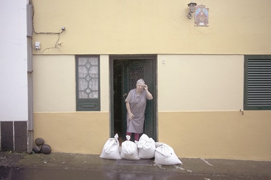
On January 15, a tropical storm hit the Azores. That’s a sentence I never thought I’d write. Tropical storms aren’t supposed to exist in the Atlantic in January, and it’s rare for them to hit the Azores at any time of year. Clearly, this storm hadn’t read the rulebook.
Just before making landfall in the Azores, the storm weakened slightly. A few hours earlier it had been a hurricane, with winds of 140 kilometres per hour (85mph). It was named Hurricane Alex, and was the first January hurricane to be seen in the Atlantic Ocean since 1955.
The eye of the storm passed just 20 kilometres (12 miles) from the island of Terceira. On the island, the strong winds ripped down trees and powerlines, and the torrential rain flooded a number of homes, but fortunately most of the damage was minor. A number of relieved locals said the storm had been like many other winter storms they had seen, and was not as bad as the wild weather which struck in December.
Despite being tiny specks of land in the middle of the vast Atlantic Ocean, the Azores are hit by tropical storms far less often than you might expect. They are protected by a persistent area of high pressure which remains near the islands throughout the year.
This generally directs storms away from the islands, and only occasionally can one sneak past when the area of high pressure temporarily eases. It’s therefore unusual for a tropical storm to hit the Azores, and for one to hit in January is unheard of.
The season for hurricanes and tropical storms in the Atlantic runs from 1 June to November 30. This is an arbitrary length of time which was picked by meteorologists to include the majority of the storms. It’s estimated that 97 percent of storms fall in this period, so clearly storms can and do form at other times of the year. However, January is a very unusual time of year for an Atlantic storm to develop, because this is the middle of winter in the northern hemisphere.
Typically tropical storms do not form in the southern Atlantic Ocean. This is primarily due to very strong winds in the upper atmosphere, which effectively ‘push over’ any storm which is trying to develop. There is only one documented case of a tropical storm which managed to form in the southern Atlantic Ocean, and that was Hurricane Catarina which hit southern Brazil in March 2004.
All the other tropical storms that develop in the Atlantic, do so in the northern hemisphere. North of the equator there are often less troublesome winds high above the earth, but in order for a tropical storm to form, there has to be an initial patch of bad weather and this has to be travelling across a warm sea which has a temperature of above 26C.
A warm sea is important to get the engines of the storm running. If the ocean is warm enough, then plenty of water will evaporate from the surface into the warm air just above it. This warm air will rise and as it does so it will cool. Cool air can’t hold as much water as hot air, so the moisture will condense into clouds. You may remember your physics teacher talking about latent heat at school, and this is what is released here as the water condenses. This extra heat warms up the surrounding air making it rise even higher.
Whilst all this is happening up in the clouds, at sea-level the air has to rush in to take the place of the rising air, and this is the wind that rages in these powerful storms. The more air that rises, the quicker the air rushes in, and the more destructive the wind becomes.
Being in the northern hemisphere, the seas around the Azores are not normally warm enough in January for this chain of events to occur.
This year, however, the sea temperatures were 1 or 2C warmer than usual, but as Hurricane Alex developed, they were still only about 22C (72F). This is much lower than is usually required, but the storm managed to overcome this obstacle because the temperature of the air high above the earth also happened to be unusually low. This meant that 22C was just about sufficient to start the air rising and enable a tropical storm to develop.
Whilst the rare January hurricane developed in the Atlantic, another storm, Pali, developed in the middle of the Pacific. Pali was never a threat to land, but it was another one for the record books.
It was the earliest named storm ever to be seen in the Pacific, and it was the first time on record that there had ever been simultaneous storms in January in both the Atlantic and the Pacific. Given this surprising start to the year, 2016 could well turn out to be rather a wild one weatherwise.

SURVIVAL INSTINCT: A woman stands as sandbags are placed outside houses to protect against heavy rains and winds during the passage of Hurricane Alex in Ponta Delgada, Azores, Portugal.
