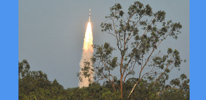
The Polar Satellite Launch Vehicle (PSLV-C27) carrying India’s fourth navigation satellite IRNSS-1D, lifts off from Satish Dhawan Space Centre in Sriharikota yesterday.
IANS/Sriharikota, Andhra Pradesh
India successfully put its fourth navigation satellite into orbit in copy book style yesterday, bringing the country a step closer to having its own satellite navigation system.
Exactly at 5.19pm, the rocket - the Polar Satellite Launch Vehicle (PSLV-C27) standing around 44m tall and weighing 320 tonnes - tore into the clear blue evening sky with fierce orange flames at its tail.
The expendable rocket had a single but important luggage, the 1,425kg IRNSS-1D.
The rocket blasted off from the second launch pad at the Satish Dhawan Space Centre here, around 80km from Chennai.
For onlookers the rocket looked like an inverted flare/torch with a long handle as it gathered speed amidst the cheers of the Indian Space Research Organisation (ISRO) officials and media team assembled at the rocket port here.
At the rocket mission control room, ISRO scientists were glued to their computer screens watching the rocket escaping the earth’s gravitational pull.
At around 20 minutes into the flight PSLV-C27 spat out IRNSS-1D.
Immediately on the successful ejection, scientists at the mission control centre were visibly relieved and started clapping.
“Despite the initial hiccup in the form of some problem with one of the sub-systems in the satellite and postponement of the launch date, today the satellite has been successfully put into orbit,” ISRO chairman A S Kiran Kumar said after the launch.
Soon after the ejection into the orbit, the satellite’s solar panels were deployed.
The satellite’s control was taken over by the Mission Control Facility (MCF) at Hassan in Karnataka.
The MCF will manage the satellite’s orbit raising operations firing the on-board motors till it is placed in the circular geosynchronous orbit.
The system is similar to the global positioning system (GPS) of the US (24 satellites), Glonass of Russia (24 satellites), Galileo of Europe (27 satellites) and China’s Beidou (35 satellites).
While GPS and Glonass are fully functional global systems, the Chinese and the Japanese systems are offering regional coverage and Europe’s Galileo is yet to become operational.
The IRNSS will provide two types of services - standard positioning service and restricted service. The former is provided to all users and the latter is an encrypted service for authorised users.