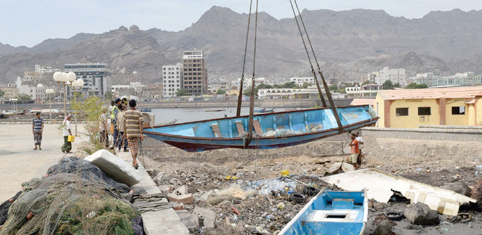
Yemeni men lift a damaged fishing boat in southern city of Aden, about 500km away from Mukalla City, after Tropical Cyclone Chapala hit.
By Steff Gaulter
Another week, another tropical cyclone! Last week we were talking about Hurricane Patricia in the Weather Addict, which was the strongest recorded cyclone ever to make landfall. This week, it’s Tropical Cyclone Chapala which has made the headlines after it slammed into the coast of Yemen.
This cyclone was big news, mostly thanks to its rarity; tropical cyclones don’t often hit the Arabian Peninsula. The last time that the peninsula was struck by one was in 2010, when Tropical Cyclone Phet slammed into Oman. Before that it was 2007, when again Oman was in the firing line, this time from Tropical Cyclone Gonu.
The Arabian Peninsula is rarely hit by tropical cyclones because not many storms form in the Arabian Sea and those that do are usually steered east by the atmosphere. This ensures that most of them miss the peninsula, but Tropical Cyclone Chapala managed to track towards the west. This is unusual and its rarity brought even more danger, because the population that was affected by Chapala had no experience of tropical cyclones and precious little resources to cope with severe weather.
Much of the coastline of Yemen is an empty rugged terrain. There are very few towns or cities along it. Unfortunately, Chapala managed to make landfall very close to one of the country’s largest cities. Mukalla is a major seaport and home to an estimated 300,000 people. Tropical Cyclone Chapala came ashore approximately 75 kilometres (45 miles) to the west of the city shortly after 4am local time on Tuesday, November 3.
Even before the cyclone made landfall, the residents of Mukalla were already suffering from hardship. In April, Al Qaeda in the Arabian Peninsula had stormed the city, seizing government buildings, releasing prisoners and stealing millions of dollars from the bank. Some reports suggest that the city is still under control of the group.
This hardship was exacerbated by Tropical Cyclone Chapala, although fortunately the cyclone did ease significantly before making landfall. Just a few days earlier, it had been the second most powerful storm ever recorded in the Arabian Sea, only topped by 2007’s Cyclone Gonu. The winds had been estimated to be 250 kph (155 mph), which would have made it the equivalent of a category four hurricane on the Saffir-Simpson scale, which is the scale used to rate the strength of hurricanes in the waters around the Americas.
As the storm bore down on the coast of Yemen, the outer fringes of the storm started to move across land. This created friction, which started to reduce the strength of the storm. Near the coast, the winds high up in the atmosphere were stronger. These winds tried to ‘push over’ the storm, and in doing so, started to ruin its circulation. The storm also started to drag in air which had been sitting over the Arabian Peninsula. As we all know, the air here is very dry and this dry air started to dampen down the storm. This ensured that by the time Chapala made landfall, the sustained winds had fallen to 130kph (82 mph), the equivalent of a category one hurricane.
The weakening of the storm prevented the residents of Mukalla having to face the major devastation which would have been caused by the equivalent of a category four hurricane. However, the rain and the storm surge were still major issues.
The storm surge caused by Tropical Cyclone Chapala was one of the biggest storm surges ever seen along the Yemeni coastline. The surge would have been even greater if Chapala had been on the other side of India, in the Bay of Bengal. This is because the Bay of Bengal is quite shallow, and is curved in a manner which funnels the water to a point, both of which enhance the height of a storm surge. The Arabian Peninsula, on the other hand, rises steeply out of the Arabian Sea, and the coastline is far straighter. The natural topography helped to reduce the storm surge, but in a region where storm surges are virtually unheard of, the onslaught of sea water was a nasty shock.
Rain was also a major problem for those living in Mukalla. The city normally expects approximately 70mm (2.8 inches) of rain in an entire year, just short of Doha’s annual average of 75mm (3.0 inches). Tropical Cyclone Chapala delivered several times this in just 24 hours. Days where we have seen over 40mm of rain have lead to flooding in Doha, so it’s clear that Chapala would have triggered major problems in Mukalla.
It’s also worth remembering that the city of Mukalla is not like Doha. The houses are not as well built, and the city sits in a valley. When it rains, the water does not simply sit on the surface like it does in Qatar, it races down the mountainsides, towards the valley. When the rain poured from Cyclone Chapala, the water hurtled downhill, creating torrents of water and triggering flash floods that ripped through people’s homes and businesses.
Fortunately the track followed by this cyclone is unlikely to be repeated in the near future. However, the residents of Mukalla now desperately need aid, but this is easier said than done in a region ravaged by war.
(The author is Senior Weather Presenter at Al Jazeera English channel. She can be contacted on [email protected] or on Twitter at @WeatherSteff)