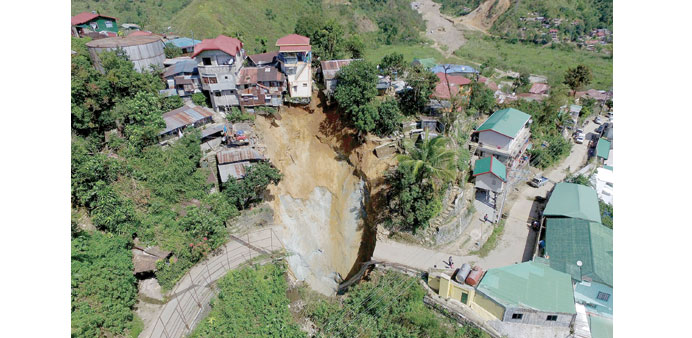
This handout photo taken on October 23 and released by Office of the Civil Defense-Cordillera Autonomous Region shows an aerial shot of a road which collapsed October 22, swallowing four houses and creating a sink hole following heavy rains brought on by typhoon Koppu, in the mining town of Itogon, Benguet province north of Manila. No one was reported injured or killed in the incident.
By Steff Gaulter
The Philippines has been battered by yet another typhoon. This year there has been a record-breaking number of storms, and the Pacific Ocean has seen the lion’s share.
The latest storm was Super Typhoon Koppu. Typhoons are huge rotating storms that feed off the warm waters of oceans. They are exactly the same as hurricanes or tropical cyclones, but are given different titles in different parts of the globe. Confusingly, the Philippines also have their own naming system for the storms as well, so Koppu is also known as Lando.
In the waters around the Americas, these huge storms are called hurricanes and are given a rating based on their wind speed. The scale is called the Saffir-Simpson scale and it runs from 1, which is the weakest, to 5, which is the most powerful. This scale isn’t officially used in the Pacific region, but unofficially many meteorologists use it as a reference, in order to fully appreciate a storm’s strength.
Typhoon Koppu intensified into the equivalent of a category 4 hurricane on October 17. This meant its winds had become stronger than 209 kph (130 mph) and the storm was capable of inflicting severe damage on even well-constructed buildings. Staggeringly, Koppu was the nineteenth storm to reach category 4 status in the northern hemisphere this year. This set a new record, far higher than the average of 12.5 and, even more surprisingly, only one of them formed in the Atlantic, all the others were in the Pacific.
Given that it is still October, there is a strong likelihood that even more cyclones which are as strong as a category 4 hurricane will form before the end of the year. In fact, the total has already risen above 19, after Super Typhoon Champi joined the hall of fame on October 18. Fortunately Champi only affected Japan’s sparsely populated Volcano Islands.
It was with the strength of a category four hurricane that Koppu slammed into the Philippines. As expected, the storm brought extensive flooding and widespread damage as it crossed the country. It was the strongest cyclone to hit the island of Luzon in five years (the devastating Super Typhoon Haiyan struck Leyte, an island to the south), but it hit a part of the island that was relatively sparsely populated. Thankfully this initially kept the death toll to a minimum.
The reason that tropical cyclones often turn deadly isn’t simply due to the strength of the winds. There are also two other hazards which can be just as destructive: namely the torrential rain and the storm surge. Super Typhoon Haiyan, for example, was the strongest cyclone ever to make landfall. No one was able to measure the winds directly, but from satellite images they are estimated to have been around 305-315 kph (190-195 mph). These would obviously have caused major damage, but it was the storm surge that really caused the devastation.
A storm of this strength pushes a great wall of water ahead of it. Tacloban is situated at the head of a bay, which funnelled the water, amplifying the surge to over five metres (16 feet) high. This giant wave was higher than most of the city of Tacloban, and had the same effect as a tsunami. The only difference is that as the waves hit, the city was being smashed by winds of over 300 kph.
In the case of Koppu, the main threat from the storm was from the amount of rain. It’s important to remember that how much rainfall that is delivered by a tropical cyclone bares no relation to the wind strength of the storm. Instead it is dependent on the speed that the cyclone is moving. If the storm moves quickly, then the time that the rain is falling is kept brief. If it is moving slowly, however, the rain can fall for days. This will not only trigger flooding, but as the ground becomes saturated, it will also increase the risk of landslides.
After crossing Luzon, Koppu turned north and churned slowly up the west coast of the island. The winds had eased when the storm had crossed land, but the rain continued to pour. With the storm moving at less than 10 kph (6 mph), the country endured days of relentless rain. Flooding and landslides were inevitable, leaving many thousands of people homeless.
The Philippines is no stranger to torrential rain. In 1911, it was reported that a staggering 2,200mm (87 inches) of rain fell on the city of Baguio in just four days. This obviously caused widespread flooding and major loss of life. However, while torrential rainfall can clearly be devastating, the rain from tropical cyclones is essential to the country. It is estimated that cyclones are responsible for approximately 30 percent of Luzon’s annual rainfall. If the storms ceased, there would be a crippling drought, like we are currently seeing in many other parts of Southeast Asia.
This year the tropical cyclones are showing no signs of abating and the reason for the increased activity is believed to be thanks to El Nino. El Nino is the slight warming of the surface waters of the Pacific Ocean. Strangely, whilst it is known to reduce the number of tropical cyclones in the Atlantic, it is encouraging their formation in the Pacific.
The current El Nino event is one of the strongest on record and is not expected to start to weaken until the spring of 2016. This would mean that there is the risk of seeing plenty more powerful cyclones in the coming months. Those who live in the Philippines will be hoping the next ones don’t make landfall.