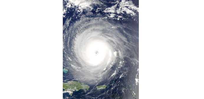
CAPTURED: MODIS instrument on NASA’s Terra satellite captured this true-colour image of Hurricane Isabel about 400 miles north of Puerto Rico on September 14, 2003. At the time, Isabel was packing maximum sustained winds of 155 miles per hour, making it a rare and powerful Category 5 hurricane on the Saffir-Simpson Hurricane scale. It was also the costliest, deadliest, and strongest hurricane in the 2003 Atlantic hurricane season, with 17 direct and 34 indirect fatalities. Photo: Wikipedia/Jacques Descloitres, MODIS Rapid Response Team, NASA/GSFC
By Steff Gaulter
There’s no escaping the heat in Qatar now! It’s seriously hot and even in the evenings the heat is almost unbearable. This is the time of year the temperature soars in most parts of the northern hemisphere, not just Qatar. Needless to say however, there’s a huge difference between the weather in Qatar and that in more northern parts of the globe. For a start, while we in Qatar are likely to endure relentless sunshine for the foreseeable future, elsewhere the heat will bring some far more active types of weather.
The rising temperatures around the Americas increase the risk that a hurricane may develop. Like most meteorologists I know, I am fascinated by these huge tropical storms due to their immense power. The hurricane season is therefore a time of great interest and while no one ever wants anyone to suffer, to see the distinctive swirl of a hurricane in satellite pictures is enough to make the hair on the back of my neck stand on end.
The Atlantic Hurricane Season officially runs from June 1 until November 30, but these are simply dates that have been picked by meteorologists. Hurricanes could form at other times of the year, but between June and November is simply the time when they are more likely. As if to prove that these dates aren’t set in stone, the first storm of this year, called Ana, developed a month early.
This early development is unusual, but it’s not unheard of. The last time a storm formed this early was in 2003, and storms have been known to develop even earlier. Back in 1908, a tropical storm formed on March 6, almost three months early.
Despite this year’s first tropical storm appearing so early, the 2015 hurricane season is forecast to be slightly below average. The Climate Prediction Centre in the US expects there to be between 6 and 11 named storms, of which 3 to 6 could become hurricanes. The average each year is 12 named storms with 6 becoming hurricanes.
The main reason for the expected lack-lustre season is the return of our friend El Nino. El Nino is the slight warming of the surface water of the Pacific Ocean. The change is usually less than 1.5C, which sounds fairly insignificant, but it can have a dramatic effect on the weather around the world. It’s a natural phenomenon which happens every three to five years, and lasts for about eighteen months.
This temperature change in the Pacific Ocean directly affects the weather in certain parts of the world. In Peru, there is often more rain than usual along the coast, but in Indonesia there is far less rain than average. Further afield and there is a knock on effect, meaning many other parts of the world also see their weather altered; Eastern Australia and South Africa are prone to drought during an El Nino year, while the southern states of the USA and parts of South America are often hit by flooding.
Another link that has been uncovered is the link between El Nino and the Atlantic hurricane season. Now that El Nino has developed in the Pacific, the wind and pressure patterns around the Americas have changed and this is expected to suppress the development of tropical systems.
As the hurricane season progresses, El Niño is expected to intensify. This would increase its influence and could well reach a peak during the months that are usually the most active of the season. However, forecasting El Nino is still notoriously difficult and while there are great uncertainties when it comes to predicting the on-set and length of the phenomenon, its strength is even more problematical.
While the Atlantic Hurricane Season is expected to be suppressed, it’s important to remember that tropical storms are not only confined to the Atlantic Ocean. To develop, a storm needs to feed off warm sea water and therefore can form in many oceans near the tropics. Tropical storms have also been known to affect the Arabian Peninsula, but here they are called tropical cyclones, rather than storms or hurricanes.
Fortunately tropical cyclones that effect the Arabian Peninsula are fairly rare. The ones that do develop generally do so in the onset of the summer monsoon, which means that they usually form in the first week of June. This year Tropical Cyclone Ashobaa developed on June 6 and brought widespread flooding to southeastern Oman.
Oman is often in the path of Arabian cyclones, but Qatar is not. Generally the storms are encouraged east by the prevailing winds and usually end up over southern Iran or Pakistan. In the unlikely event that a storm does manage to navigate the waters of the Gulf towards Qatar, the storm will encounter such dry air that it will almost certainly have disintegrated before reaching us.
As the Americas continue to nervously watch the skies as the hurricane season unfurls, it’s reassuring to know that we are unlikely to be struck by one of the monstrous storms. However, as I gaze out of the window I can’t help thinking that the prospect of a small shower would be very appealing.