By Steff Gaulter
The first storm of the Atlantic Hurricane Season has finally formed. Although we have seen a number of tropical cyclones churn in the seas to the west of Mexico, this is the first one to develop in the Atlantic this year and it certainly took its time. The season officially started on June 1, but this year we had to wait until June 30 for a storm to develop. This is the longest we’ve had to wait for a storm since 2004, but as well as being late, it was also unusually strong.
The storms of June and July are generally fairly weak systems, but this year’s storm had other ideas. It grew out of a cluster of thunderstorms that drifted off the coast of the Carolinas. It ambled towards the Bahamas, and began to intensify to the east of Florida.
The rain across the region turned heavy, with Miami reporting 98mm (3.9 inches) on June 29 and 30, and Freeport in the Bahamas reporting 149mm (5.9 inches) in just 24 hours.
The system intensified by feeding off the warm waters of the ocean. This is the power source of a tropical system, whether it is a tropical depression, tropical storm or a hurricane. Great amounts of energy are transferred into the atmosphere when warm water evaporates from tropical seas.
The sun provides the energy necessary to turn the water into water vapour, and once the vapour is in the atmosphere, the energy is like a coiled spring, primed and ready to be released.
As the humid air rises, it cools and the water vapour condenses. This releases the energy, producing the towering cumulus clouds and rain seen within a tropical storm. The warmer the waters are, the more accessible the energy is. It’s no coincidence that the first system to form this year developed over the very warm waters of the Gulf Stream Current, which are over 0.5C (1F) warmer than usual for this time of year.
In addition to having favourably warm waters to feed from, the system was also in a part of the atmosphere where the winds encouraged development. If the winds are fairly similar throughout the atmosphere, something known as low ‘wind sheer’, then a system isn’t disrupted as it grows vertically throughout the atmosphere. The winds to the east of Florida had low wind sheer as the storm developed, and the system took advantage of this, growing extensively.
Usually storms that form just off the shore of Florida don’t become particularly powerful. This is because they are too close to land to be able to intensify before hitting the coastline, but the sea temperature, the low wind sheer and the fact that initially the system was moving very slowly, all enabled this storm to grow as it headed northwards, up the eastern seaboard of the US.
When the winds within a storm reach 63kph (39mph), the system becomes classed as a tropical storm, and at this point a system earns its name. The first storm this year was given the name Arthur, and it continued to grow.
By the time it made landfall, it was a category two hurricane on the five point Saffir-Simpson Scale which rates hurricanes. A category two storm may be the second weakest category, but it still has sustained winds of over 154 kph (96 mph), which can topple trees and powerlines, and inflict major damage to roofs of even well-constructed houses.
The website of US National Hurricane Center warns that near-total power loss is expected from a category two storm, with the possibility that black outs could last from several days to several weeks.
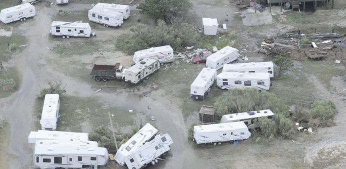
As Hurricane Arthur slammed into North Carolina, a 1.4m (4.7ft) storm surge raced up the Oregon Inlet. The wind howled, with the strongest gust reported on land being 163kph (101mph) at Cape Lookout. Power cuts and significant coastal flooding and causing erosion were seen across the coast of North Carolina.
The system then ran up the east coast of the US. For many states it didn’t cause too much damage, as it was moving quickly, so the onslaught from the weather was fairly short-lived. However, when Arthur moved across Massachusetts, the moisture interacted with a stalled frontal boundary. An unenviable 200mm (7.9 inches) of rain fell, inevitably causing flooding.
Arthur then became what’s known as ‘post-tropical’ before heading into Canada. Post-tropical is simply a term which means that the system no longer has tropical characteristics, and doesn’t need a warm sea to be its energy source. However, the term has no bearing on the storm’s strength. As Arthur hit Canada, it was certainly still packing a punch.
The storm pelted eastern Canada with St Stephen reporting 142mm (5.6 inches) of rain and a gust of wind of 123kph (76mph) on Brier Island. Trees and powerlines were torn down, and at the height of the storm, over 290,000 homes and businesses lost power.
We often hear about hurricanes in the waters around North America, but a direct hit from one of these storms is not as common as you might think. It may surprise you to hear that the last time a hurricane struck the mainland US was Hurricane Isaac in 2012, and the last category 2 storm to hit the US was back in 2008, when Hurricane Ike slammed into Texas.
Many of you probably remember the devastation from Hurricane Sandy in October 2012, but technically we cannot include Sandy as it was no longer a hurricane when it made landfall.
Despite its slow start, the 2014 Atlantic Hurricane Season could still turn out to be an active season. It only takes one huge storm for the season to go down in history. Hurricane Arthur may not have been destructive enough for this, but it will certainly be remembered by many residents of the east coast of North America for many years to come.

