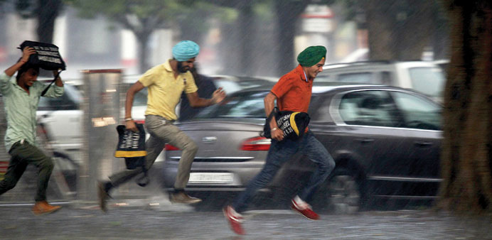
MONSOON MANIA: Men run for cover during a heavy rain shower in the northern Indian city of Chandigarh. India’s monsoon is expected to bring below-average rainfall this year, with precipitation between June and September seen between 90 and 96% of the long-term average.
By Steff Gaulter
The monsoon has finally crept over the tip of India. It certainly took its time this year. It’s supposed to cover all of Tamil Nadu by June 1, but this year it was only the southern half of the state that had seen the monsoon set in by June 8, one week after its scheduled arrival.
The monsoon is always a hot topic of conversation across India and Bangladesh. For some parts of the region, this will almost be the only rain that they see in the entire year. This is the time to plant crops and wait.
As you might expect, the amount of rain which falls during the monsoon is critical, particularly to farmers. People who work in the fields are anxious to know when the rains will arrive and how much water they will bring. There are estimated to be as many as 600mn farmers across India alone and they all know that there is a direct relationship between their livelihoods and the strength of the rains.
A generous amount of rain means the farmers should have an abundant harvest. This is not only good for the farmer, but also for the local community, as food prices will remain low. However, if there is too much rain, or too little, this can cause problems for the entire country. In India, 2008 was one of those years with far too much rain. Crops and homes were washed away, and over 2,400 people lost their lives. Just one year later, in 2009, the opposite problem occurred when the rains failed, leading to shrivelled crops and soaring food prices.
Even in a year with an ‘average’ amount of rain, somewhere always receives too much and somewhere else won’t receive enough. Last year for example, the northeastern states only received about 65% of their average monsoon rainfall. The farmers there desperately hoped for more, but in the west of the country, the rain didn’t stop. The state of Madhya Pradesh saw almost 50% more rain than average.
This year the prediction is for below average monsoon rains. As regular readers of the Weather Addict will know, I am normally very sceptical of long range forecasts, and the track record of the Indian Meteorological Department certainly hasn’t done anything to restore my faith in them. According to a report from Deutsche Bank analysts in 2012, India’s weather office has only managed to forecast the June-September monsoon’s precipitation correctly five times, since 1994. That’s pretty poor.
However, this year there is increased optimism in the accuracy of the forecast, because it is likely to be influenced by the El Nino conditions which are developing in the Pacific Ocean. El Nino is the slight warming of the surface waters of the Pacific. This may sound insignificant, but it can have a major influence on the weather around the entire globe.
One of the things that has been noticed, is that El Nino often subdues the monsoon rains. Although the result isn’t guaranteed, it is a fairly good indicator of the probable outcome.
If the rain is lighter than usual, as well as arriving later than usual, this could spell disaster for the millions of farmers across India and Bangladesh, especially as, in some parts of the region, the rain over the past few months has already been disappointing.
The fact that there is rain ahead of the monsoon confuses many people. Strictly speaking, the monsoon refers to a change in the wind direction, rather than the onset of rain. Having said that, heavy rain usually falls as the wind direction changes, but showers are also likely before and after the wind change.
In northeast India and Bangladesh, the pre-monsoon rains often bring substantial amounts of rain.
They usually arrive in the form of immense thunderstorms, which can be as deadly as anything seen in Tornado Alley in the USA. They’re known as Kalboishakhi, and they’re formed when cool air from the northwest slams into the hot humid air feeding northwards from the Bay of Bengal. The contrast in the two types of air leads to explosive results, often producing damaging hail, torrential rain and even tornadoes.
Their name is a bit of a mouthful, but comes from the fact that the storms form after the beginning of Boishakh, which is the first month in the Bangla Calendar, the calendar of Bangladesh. Boishakh starts on April 14 or 15, and is officially known as the start of summer across the region. The on-set of the monsoon rains mark the end of the Kalboishakhi season.
This year, however, there was a noticeable absence of low pressure systems in the Bay of Bengal. This effectively cut off the feed of warm, moist air to Bangladesh and Northeast India. Instead the air above the land was hot, and very dry. The temperatures soared higher than usual and there were far less Kalboishakhi than usual.
The 2013 monsoon was below average in northeast India and Bangladesh, as were the premonsoon rains this year. If this is now followed by another below-average monsoon season, this could spell disaster for the millions of farmers in the region. We will just have to hope the forecast is wrong; after all, it wouldn’t be the first time.