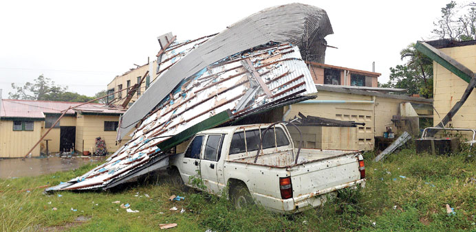
SWEPT AWAY: A fallen roof lies on a car in Cooktown, Queensland, Australia, last week. Tropical cyclones get their energy from warm sea water, and by the time the storm made landfall in Queensland, the winds were gusting over 225kph (140mph).
By Steff Gaulter
Powerful Tropical Cyclone Ita slammed into Australia on April 11, causing widespread flooding and tearing roofs from houses. After developing approximately 1,800km (1,100 miles away) over the tiny Solomon Islands, the storm had gathered strength as it moved across the warm seas to the northeast of Australia.
As the storm formed over the Solomons, the rain was exceptional. A total of 767mm (30.2 inches) of rain fell in the capital, Honiara, in four days. An eye-watering 318mm (12.5 inches) of that fell in just 24 hours. Wherever you are in the world, such a phenomenal amount of rain in such a short period is bound to give you flooding. London receives an average of 611mm (24 inches) in an entire year, and Sydney receives 1,222mm (48 inches).
The immense amount of rain caused the Matanikau river to burst its banks sending a torrent of water through the streets of the capital. Homes and bridges were swept away, and 59 people are missing, presumed to have died.
Another 49,000 people are staying in evacuation shelters. Many people are too scared to return to their shattered homes, for fear of landslides. The concern now is that lack of drinking water and sanitary conditions may lead to diseases such as dysentery and cholera.
The Solomon Islands are located to the northeast of Australia and have a tropical climate. Therefore the islands do expect more rain than London or Sydney rain during the year, but never this much. There are two distinct weather systems that affect the islands, and both of them bring a good deal of rain.
The wettest period is between November and April. This is when Honiara would expect around 300mm (11.8 inches), but this would be in a month, not in a day.
The rainy season in the Solomon Islands is caused by the line of thunderstorms that stretches around the globe. Some of you may remember that I mentioned this line of storms (known as the ITCZ) in the Weather Addict two weeks ago.
It’s caused by the sun’s intense heating, which makes the air near the equator rise, cool and condense to form huge rain-bearing clouds. This line of thunderstorms follows the sun northwards during the northern hemisphere’s summer, and southwards as summer takes hold in the southern hemisphere.
At any time of year, you can look at a satellite picture of the world, and see this line of thunderstorms. In some places it will be more intense, and in others it will be rather patchy, but the line is always present.
When this line of thunderstorms moves southwards during the southern hemisphere’s summer, it moves over the Solomon Islands. Although every single day is not wet, the majority of days are. In Honiara, 70% of the city’s rain falls in this period.
Even after this line of tropical thunderstorms moves north in the autumn, the islands are still a magnet for rain.
This is officially the dry season, but Honiara still sees more than 70mm (2.8 inches) of rain every month. This is due to the prevailing winds which sweep up from the southeast. These have travelled across the warm seas and are heavily laden with moisture. The heaviest rainfall is on the east of the islands, but even in the west, there is still plenty of rain.
In short, the Solomon Islands are a very wet place. If you are planning a visit, then an umbrella should be the first thing that you put in your suitcase! In addition to the two distinct rain-bringing seasons, there is also the risk of seeing a tropical cyclone. Between 1969 and 2010, 41 cyclones passed within 400km (250 miles) of Honiara, an average of one cyclone every season. Of course, cyclones are rather less reliable than that, and some years there will be none and others there could be up to five.
Generally, however, cyclones are fairly weak when they cross the islands and the damage is limited. This is because the region to the east of the islands is an area where tropical cyclones usually develop, so the storms are normally in their infancy when they cross the country.
The low pressure that developed over the islands at the beginning of this month was also in its infancy, however, it was also almost stationary. This meant that the clouds continued to swirl over Honiara, and rain continued to pour. Even for the soggy archipelago, the rains were exceptionally heavy.
After four long days, the system moved away from the Solomon Islands and crept across the Coral Sea towards Australia. It developed into a tropical cyclone, and began to strengthen.
Tropical cyclones get their energy from warm sea water, and by the time the storm made landfall in Queensland, the winds were gusting over 225kph (140mph). Major flooding hit parts of the state, but despite the strength, the damage was far less than it was in the Solomon Islands.
The fact that an area of low pressure can cause more damage and more destruction than an intense tropical cyclone may surprise many people. However, the amount of rain that a storm generates and the strength of its winds are not always correlated.
This means it’s impossible to judge the impact of a storm simply by its wind speed alone. This may well be a blessing for me, because if forecasting the weather was that easy, I’d probably be out of a job!