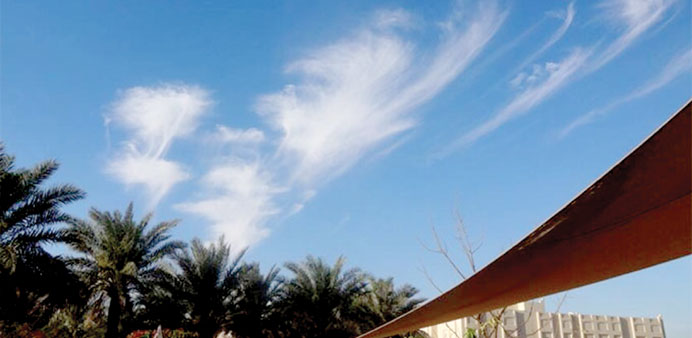
These delicate clouds were high above the city, at a height of 7,400m. It was their icy nature that gave the clouds their fragile appearance, but their shape was generated by the fact the ice was falling slowly. Photograph: Kamahl Santamaria
By Steff Gaulter
People have been sending me pictures of clouds. Usually it’s the other way round, but on Monday I wasn’t the only one with my camera lens aimed at the sky. The interest was caused by the fine, wispy clouds that looked like pieces of cotton wool, or tufts of hair, which were dotted across the skies above Doha.
These delicate clouds were high above the city, at a height of 7,400m (24,000ft). At this height, the temperature would be around -25°C (-13°F), so any moisture would be ice rather than water droplets. It was their icy nature that gave the clouds their fragile appearance, but their shape was generated by the fact the ice was falling slowly.
When a water droplet is in a cloud, it can continue to grow until it is too heavy to be suspended in the air. At this point, it will fall towards the earth as a raindrop. The same effect happens in a cloud made of ice too, the only difference being that the falling particle in this case will be ice rather than water.
On Monday, the ice within the clouds started to fall towards Doha, but as in this case, not all raindrops or ice particles reach the ground.
Sometimes there may be warm air below the cloud, or dry air, and this would encourage the raindrops to evaporate. However, this high in the atmosphere, ice doesn’t melt. Instead, in certain conditions ice will turn directly into a gas. This is called sublimation and you are probably most aware of it in terms of carbon dioxide, rather than water.
Most people are quite familiar with ‘dry ice’, which is the solid form of carbon dioxide; this is the substance that gives off the clouds of smoke at a pop concert. Dry ice is simply frozen carbon dioxide, which sublimates, or becomes a gas, at the chilly temperature of -78.5 °C (-109.3°F).
Clearly we all know that if you bring an ice cube out of the freezer it will melt, but if the air is dry, the air pressure is low then it can turn into a gas. High up in the atmosphere, the air pressure is lower than close to the ground, so if the air is also dry this can encourage sublimation.
The other factor needed for ice to turn into vapour is a good deal of energy, and high up in the atmosphere, above the majority of the clouds, there is often a good deal of sunlight, which can supply the energy needed to encourage the ice to sublimate into a gas.
On Monday, the ice particles initially fell towards Qatar, but evaporated in the drier air beneath it. The streaks that you can see below the main area of cloud are the ice particles falling. These are known as fall streaks or virga, but as we saw on Monday, they don’t fall in a vertical line.
Instead the fall streaks have a distinctive hook shape, because the clouds are being pushed along by the wind and the ice particles fall progressively more slowly as they shrink. Therefore by the time the drops have almost completely disappeared they are hardly falling at all and the streak’s tail is almost horizontal.
This means that you can tell the direction that the wind is blowing high up in the atmosphere just by looking at the shape of the mare’s tails; the tails point in the direction that the wind is coming from.
It was great to see so much excitement caused by such a small cloud, and fortunately during the next few weeks there are likely to be more clouds to spot in Qatar.
April is usually quite a damp month and we have had a good few days of rain in April very single year for the past 10 years except for 2008. People often forget this and claim that it never rains this late in the year, but it’s just our mind playing tricks on us. In fact, the rain in April can be heavy and it’s not unusual for it to last almost a week.
This rain marks the transition from the winter weather set up to the summer one, so after this we can expect our weather to be fairly predictable. From May onwards, no longer can we expect to see fog and thunderstorms, instead, the skies will mostly be blue; it would be unusual to see any rain until October at the earliest.
Of course things are going to get increasingly hot. So far this year the weather hasn’t been too unbearable, but the temperature will now begin to soar. The average daytime high temperature in April is 31.9°C (89.4°F), but in May that will soar to a sticky 38.2°C (100.8°F).
Most people would agree that this is a little bit too hot, so if it is a bit cool and wet at times this month, then we should definitely celebrate!