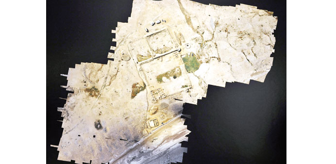
CONNECTING THE DOTS: A detailed high-resolution image of the Ruwayda site as captured by the drone.
A microdrone using aerial photography has provided high-resolution maps of the Al Ruwayda archaeological site in Northern Qatar, writes Anand Holla
By their very nature, technology is hooked into the future and archaeology is hung up on the past. Their contrasting interests tell us that never the twain shall meet. That is until the brains behind a unique interactive exhibition decided to explore the irony of technology enabling archaeology to be understood wholesomely and experienced intimately.
A microdrone — or Unmanned Aerial Vehicle (UAV) — using aerial photography has provided high-resolution maps of the Al Ruwayda archaeological site in Northern Qatar; it was certainly the hero of the Lines in the Sand exhibition.
Welsh archaeologist Dr Andrew Petersen, who is the Project Director of The Wales Qatar Archaeological Project (WQAP), looked at a large wall hung with various images taken from the microdrone that carried out the aerial survey work, and said, “Often, archaeologists hold exhibitions for other archaeologists and archaeology enthusiasts.”
Walking through the vast exhibition hall at the Virginia Commonwealth University in Qatar (VCU-Q), he explained why archaeology had to be brought into the contemporary gallery space.
“This is a different way of communicating the kinds of things we do and make it accessible to people who won’t necessarily go to an archaeological exhibition.”
“Since we already had this link with VCU-Q through the Qatar Foundation’s Qatar National Research Fund grant, we thought it would be interesting to use their expertise in creativity and communication,” said Petersen.
Interesting would be to put it rather mildly. The compelling exhibition was a creative extension of the previous collaborative research at the Al Ruwayda archaeological site which was funded by a National Priorities Research Program (NPRP) grant, and involves VCU-Q, the University of Wales and Qatar Museums Authority.
Under Petersen, the WQAP has thus far unearthed two sites in Northern Qatar that give us valuable insight into Qatar’s illustrious history — Rubayqa which unravelled a mosque, large courtyard homes and two cemeteries, and Ruwayda, which revealed the remains of a town lined by a fortress.
“We have been excavating there for five years now. The site dates from the 18th century, possibly even 10th century. But the 1600s and 1700s is what we have got so far,” said Petersen about Ruwayda, which “stretches three kilometres along the coast, and lies next to the abandoned village of Jumail.”
While Northern Qatar has a lot many sites from the Islamic period dotted around the coast, Petersen said they focused on Ruwayda because after Al Zubarah, Ruwayda is the largest archaeological goldmine.
“Also, Ruwayda has the potential to be much older, and historically not much is known about it,” he pointed out.
The name probably derives from the Arabic term, Rawdah, which means a meadow. Ruwayda is the diminutive form of that word and refers to an area for grazing livestock.
Given the enormous size of the site, the organisations involved wanted to map it efficiently and accurately. “This seemed like a good case to test the potential of microdrone aerial photography for quicker mapping,” Petersen said.
“With the support of Qatar Foundation, we were lucky to get a very high-specification microdrone, which can do a lot more than flying pre-programmed routes,” he continued, “Using high-resolution cameras and thermal imaging devices, it’s able to produce different types of images, using heat and light. This is quite unusual in archaeology.”
What topped off such an unusual enterprise was to share it with the people — through Lines in the Sand. Diane Derr, curator of the Innovative Media Studio at VCU-Q, said, “The premise for the exhibition was to explore interactive media as a mechanism for engaging in cultural history. Typically, cultural heritage, and particularly archaeology, is very inaccessible.”
Derr said they approached interactive media as a mechanism for users to be able to access it. “Each of the process uses different technologies. We had augmented reality, interactive touch screens, 3-D gesture, and a documentary to contextualise all the projects we are doing,” she says.
Looking at the enthusiasm of visitors, the idea appeared to be spot on. Four iPads jutted out of the corners of a large glass case of sand, around which a few children huddled. They tried out augmented stratification which uses augmented reality to create spatial representation of data found in the stratification of the site.
Leap motion sensors (which sense your hands and fingers and follow their moves) controlled by Mac minis help users access and examine artefacts through hand gestures made in front of a sensor.
A couple excitedly “felt” some of the 21 silver Indian rupee coins that were kept inside the glass display case, as the sensors turned and tossed the coin on screen merely by a wave of the hand.
Found in a small cotton bag hidden within a recess in the wall at the back of a mosque in Ruwayda, the coins dated to the reign of Queen Victoria and bear her portrait.
A few steps away, a giant touch screen took you through the history of Qatar’s heritage, and in another corner, you could almost “feel” a worked bone fragment, probably of a camel, which was shaped and cut to represent an Oryx (from late 18th or early 19th century).
“We were looking at the relationship between technology and cultural heritage as a mechanism to engage users in a participatory experience,” Derr said.
“Each option leaves us with a possibility that can be explored extensively. We will further develop each of these and understand how they enable participants to engage in this information,” she added.
At the centre of the hall sat the microdrone on a mound of sand, soaking in the limelight. “They are all composite images,” Petersen said, pointing at the microdrone-snapped pictures of the site, “Each has probably about 500 different images in them.”
The precise, rectified site maps help determine the exact distances. “People are used to Google Earth. But these images are so much sharper and detailed. Also, a lot of people misunderstand the accuracy of most satellite photography,” he said, preferring them over the results obtained usually from traditional kite photography or satellites.
Petersen, who is an expert in the Islamic Archaeology of Arabia and has worked extensively on sites across the Middle East, believes that the microdrone’s aerial photography allows 3D terrain models to be easily generated from a set of ground control points.
To simplify this further, a microdrone flies essentially using waypoints or predetermined routes controlled by on-board GPS, gyroscope and barometric readings. This means that it is able to survey a grid pattern and take a series of photographs at predetermined intervals, enabling the team to produce a comprehensive, high resolution map of the surface of the site.
“So we have a series of site images using different sensing systems like visible light, near infra-red, and thermal images,” Petersen explained, “The near infra-red and thermal images, for instance, can detect things that you can’t see with the naked eye. This helps us see features of those elements in the site which retain the heat longer or lose it quicker on the ground.”
To do so, the team needs to send the microdrone on several trips. “That’s why we are flying it in the mornings and in the evenings, when the earth is either heating up or cooling down,” Petersen said.
BELOW:
1) THE FINDER: The drone flying over historical archaeological sites in Northern Qatar as part of the project. Photos by Najeer Feroke
2) UNDER THE MICROSCOPE: Augmented stratification of the site that could be experienced through the iPad and 3D modelling.
3) IMPRESSIVE: Project Director of The Wales Qatar Archaeological Project Dr Andrew Petersen
4) THE FIND: A range of materials excavated from the Ruwayda site in a display case at the exhibition.