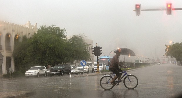
At the beginning of the month, people were asking where the first rain of the winter was. Well, I think that question has been well and truly put to bed! The storms that we saw in Qatar between November 23 and 28 were spectacular. The rain was torrential and many of the streets were flooded. Even some of the shopping centres saw the rain appearing through the ceilings, prompting workers to rush and find mops and buckets.
The storms didn’t only bring heavy rain. They also brought plenty of thunder and lightning, and some very destructive winds as well. You’ve probably all seen the images which have circulated in the press and on social media of the ‘tornadoes’ which hit Qatar. I’ve seen videos from Doha, Al Khor and Mesaieed. They were impressive windstorms and some of them looked positively terrifying, but a discussion quickly erupted, questioning whether these storms were truly tornadoes.
To be honest, some of the twirling storms I saw didn’t really look like tornadoes; they looked more like rather intense dust devils. However, some of the more powerful ones certainly did look like the real deal. Videos showed violent columns of rotating air which picked up dust and debris as the storm churned on the ground. These certainly appeared to be classic tornadoes.
According to the National Severe Storms Laboratory in the US, the strict definition of a tornado is a narrow, violently rotating column of air that extends from the base of a thunderstorm to the ground. It is the final part of this definition which leads to the question mark in the case of Qatar’s storms. Did the swirling column of air reach all the way from the ground to the cloud?
The Qatar Meteorological Agency reported that Wednesday’s swirling storms were gustnados, rather than tornadoes. You would certainly not be alone if you had never heard the term gustnado before. A gustnado looks very similar to a tornado, both are short-lived swirling wind storms, which touch the ground.
However, their method of formation is rather different. A tornado can form in a variety of ways, but the most powerful twisters develops from a very powerful thunderstorm. Many of us will be familiar with a ‘funnel cloud’, a ‘v’-shaped cloud which extends from the base of a cloud. This is often a precursor of a tornado. If the funnel cloud extends enough so that it actually reaches the ground then it is classed as a tornado. A gustnado, however, is quite different.
A gustnado only forms on the leading edge of a thunderstorm. This is where there is a strong wind coming down from the cloud, known as a downdraft. As this blast of air hits the ground, the wind spreads out, causing a rush of wind at the surface. This explains why as a thunderstorm approaches, but before the rain starts, you will sometimes notice the winds pick up.
When the downdraft slams into the ground, some of the winds spread out along the ground, while some bounce back into the atmosphere. In certain conditions, as the winds rebound back into the air, they can start to rotate. If there is a rotation, the rotating column of air is known as a gustnado.
A gustnado therefore starts at ground level and then grows upwards. They usually extend between 9 metres and 90 metres into the air, and despite the fact they are a rebounding blast of the air, they can be very powerful. The winds within them can reach up to 130kph, which is easily enough to pull down trees and powerlines and even enough to overturn a sedan car.
One important distinction between a tornado and a gustnado, however, is that they do not connect with the base of the cloud. This is what makes the system different from a tornado. Some of the videos that I’ve seen do appear to show funnel clouds, which would mean that real tornadoes could well have been present as well as gustnadoes, but trying to distinguish exactly what is happening in a short, handheld video taken on a mobile phone is nearly impossible.
To be honest, given the strength of some of the twisting columns of air, it seems rather immaterial whether they were all gustnadoes, or whether there were a few real tornadoes thrown into the mix. After all, a gustnado can be equally as powerful as a weak tornado. The important thing is that whatever they are, they are pretty powerful, and it would be wise to avoid approaching anything that looked similar in the future.
The weather in Qatar is generally benign. In the summer, the heat is extreme enough to cause heat stroke, or at times it can even prove fatal. However, for the rest of the year, we tend to take the dry, settled weather for granted. Wherever you are in the world, it’s always advisable to respect the weather, because occasionally it will throw a few surprises at us.
(The author is Senior Weather Presenter at Al Jazeera English channel. She can be contacted on [email protected]
or on Twitter at @WeatherSteff)

The storms didn’t only bring heavy rain. They also brought plenty of thunder and lightning, and some very destructive winds as well.


